Natural Disasters in History
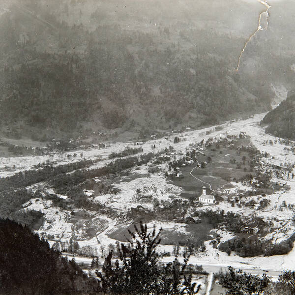
Flood Disaster Rellsbach 1910 (Vorarlberg)
After a long, snowy winter, warm weather occurred rapidly in May 1910. The resulting snowmelt combined with heavy precipitation (102 mm in 24 hours and 146 mm in 72 hours) between June 13 and 15, 1920, led to a debris flow of catastrophic proportions in the Rellsbach catchment. The landslides in the approximately 6 km long stretch of the gorge were underestimated at the time and the protection structures in the main stream built between 1901 and 1910 were flooded or destroyed, which mobilized additional debris flow material. A total of around 1,000,000 m³ of material was deposited in the local area. At the neck of the alluvial cone, the deposit height was 12 m, 200 m down the valley 8 m and up to 3 m in the distal part near the Ill river. 103 hectares of meadows were covered by gravel, 31 residential and commercial buildings were destroyed, 26 buildings were severely damaged and approx. 50% of the municipal area was covered by debris. Numerous livestock died in the water and mud masses, but no people lost their lives.
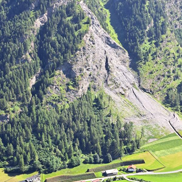
Rockslide Vals 2017
On Christmas Eve, December 24, 2017, a rockslide occurred in the evening on the orographic right flank of the Valser Valley in Tyrol, Austria. During the event, around 120,000 m³ rock material fell off the slope. The valley road was buried up to eight meters high. The fall process destroyed a rockfall protection net in the edge area and its distal extensions reached to within a few meters of existing buildings. A temporary replacement road was subsequently built on the other side of the valley and residential buildings were evacuated. Surveys in the demolition area showed numerous, partially large and deep crack formations on the orographic right next to the demolition niche as well as a number of historical, partly obviously inactive cracks.
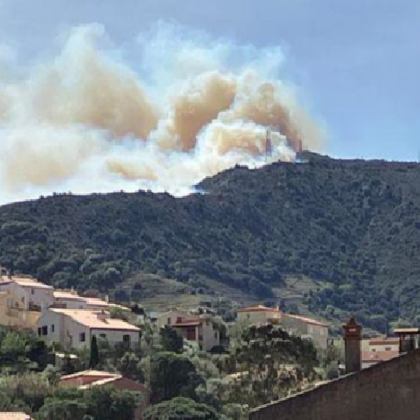
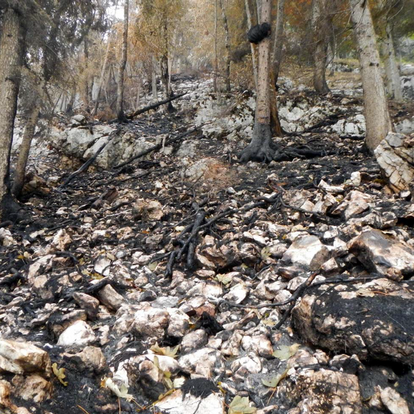
Cerbère forest fire 2023
The Cerbère area, located between the Pyrenees Mountains and the Mediterranean Sea, has been affected by 13 fires in the past. In the last 10 years, the slope below the summit peak has burnt 5 times. More recently, two successive fires have affected the Ribéral catchment area: a small one (10 ha) on July 31, 2021, which started across the border in Spain and a larger one (> 3 km²) on April 16, 2023. In April 2023, water stress conditions for vegetation were exceptional, equivalent to the average level expected for the end of a month of July, and above the record values observed to date (2008). These exceptional conditions followed the cumulative deficits of 2021 and 2022, and peaks in temperatures. On the day of the fire, the tramontane (a wind that blows from the mountains towards the sea) exceeded 100 km/h and twisting phenomena formed in the limits of the torrential watershed. The fire started near a large car park, close to the main road and the railway line, confirming the fact that fires are generally of human, rather than natural origin. After burning 700 ha in France, the fire moved down towards Spain, burning a further 170 ha before being contained after 7.00 pm.
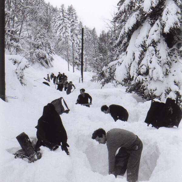
Avalanche Disaster of Blons 1954
A number of avalanches occurred in the Großes Walsertal (Austria) between January 10 and 12t, 1954. The trigger is considered to be the extreme and dry snowfall of more than 2 m within 24 hours under the influence of stormy, snow-carrying northwest winds. During these devastating avalanches, 177 people were buried in the valley, of which 80 people could no longer be rescued alive. In the community of Blons alone, a third of the houses were destroyed and a third of the mountain village's population, a total of 57 people, died. Emergency aid for Blons was provided via the first airlift in Austria's history. After the avalanche disasters in 1951, the immense personal injury and property damage in Blons led to the development and establishment of modern avalanche protection in Austria in 1954.
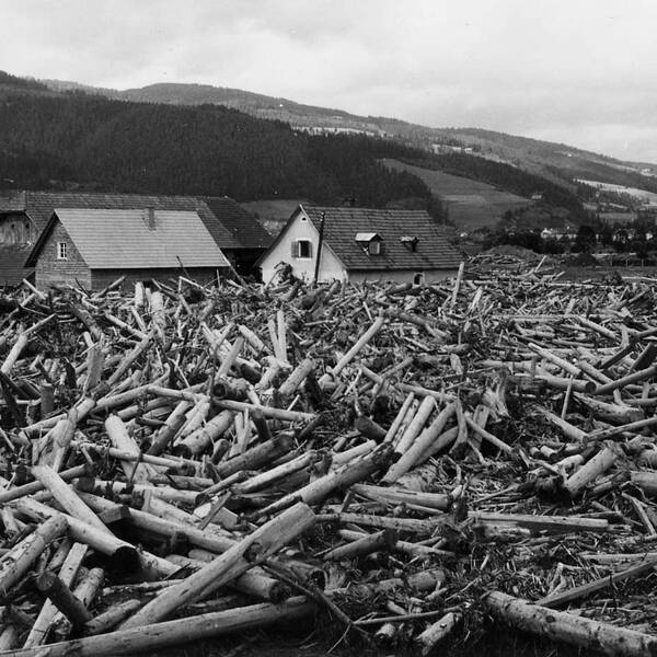
Flood of Allerheiligen 1958 (Styria)
The coincidence of a cold front and a thunderstorm resulted in rainfall of up to 500 mm in 12 hours with an hourly maximum of 200 mm in the area of the Fischbacher Alps on the night of August 12 to 13, 1958 over an area of 250 km2. Due to the high pre-moisture conditions in the area, a number of landslides occurred. A total of 280 hectares of forest land slipped. This resulted in 22,000 cubic meters of damaged wood. The combination of high rainfall, large amounts of erodible material and wood in the streams led to enormous devastation. Particularly in the municipality of Allerheiligen in the Mürz Valley, smaller settlements were isolated from the outside world for weeks and were supplied with pack animals and helicopters.
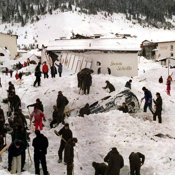
Avalanche Galtür 1999
Three snow fall periods in january and february 1999 lead to a fresh snow hight of about 4 meters in the Galtür muncipality. Due to strong winds from north, additional drifting snow accumulated in the slopes beneath Grieskogel peak and resulted in even bigger snow hights locally. On February 23, 1999 the „Äußere Wasserleiter-„ and the „Weiße Riefe-„ avalanches were triggered spontaneously. As a result of the enormous snow amounts, the avalanches reached the settlement and destroyed numerous houses. 20 people could be rescued with minor injuries, two with servere injuries, but 31 people lost their lives in this catastrophy. Besides the fatalities, property damage was estimated at 10 to 11 million euros.
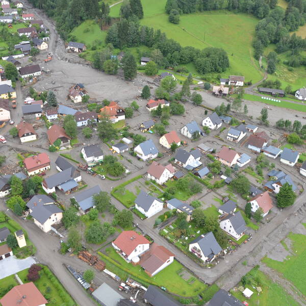
Debris flow of St. Lorenzen 2012 (Styria)
Extreme precipitation occurred between July 19 and 21, 2012 in Paltental, Styria. The combination of 141 mm of average regional precipitation with a 15-minute peak of over 40 mm together with previous rainfall events and the high pre-moisture conditions triggered landslides in the middle reaches of the Lorenzbach. The large volume of erodible material led to a debris flow that caused damage to 67 buildings, seven of which were completely destroyed. The flood heights were in some cases up to 3 m. Calculated back, the debris flow reached a peak discharge of around 500 m3/s with peak speeds of 16 m/s.
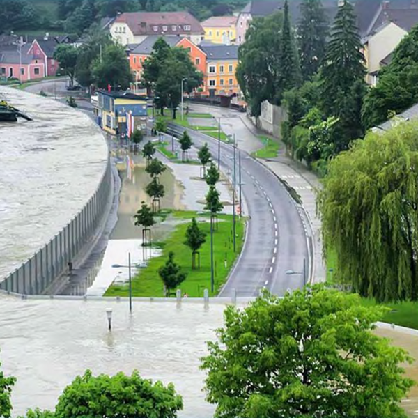
Danube floods 2013
The widespread and heavy rainfall between May 28 and June 5, 2013 caused a massive flood event along the river Danube and its many tributaries. The flood peak at the Korneuburg gauge was around 11,000 m3/s (mean discharge 1885 m3/s), which was even above the peak of the 2002 flood. In Upper Austria and Lower Austria, the mobile flood protection elements, that were built after the flood in 2002, were able to prove themselves for the first time and prevent major damage. In Vienna, the relief channel was flooded, which also prevented major damage. The 2013 flood clearly showed that measures such as technical protection devices, further development of forecasting systems, early warning or resettlement can reduce the extent of damage. For example, the damage in Marchland in 2013 was reduced to 1/20 with 25 million euros.
Hallstatt forest fire 2018
The town of Hallstatt consists of two centers: the actual town center is located in the middle of the alluvial fan of the Hallstätter Mühlbach, the 2nd center is in the valley of the Waldbach at the foot of the Echernwand in the north and the Hierlatzwand in the south. On August 21, 2018, heavy smoke was observed in the Echernwand, above the town of Hallstatt. The cause for the fire was probably carelessly discarded cigarettes at a resting area on a climbing trail. The fire developed from the original ground fire into a forest fire that spread into the tree crowns. It spread in the direction of the inclined elevator to the salt mine, which is why Salzwelten AG and its employees were intensively involved in fighting the fire from the inclined elevator. Despite the effort of police and army helicopters, the fire was only extinguished after 4 days. A fortunate circumstance was that there was almost no wind on these days, so the fire was easier to control. The intense heat development resulted in additional disintegration of the rock structure and massive rockfalls that reached the houses at the base of the wall.
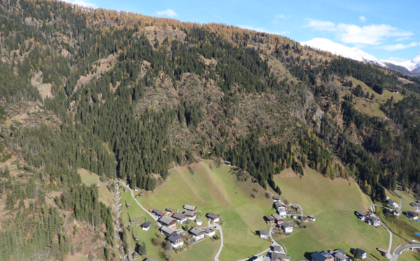
Destruction of protective forests caused by Storm Vaia 2018
The storm “Vaia” swept across the southern Alpine region on October 29, 2018 and caused significant damage to infrastructure and mountain ecosystems. Storm peaks of over 200 km/h and enormous amounts of precipitation led to numerous floods and debris flows. The high wind speeds led to countless windthrows. The protective forest in Carinthia and East Tyrol is particularly affected, where around 60% of the damaged areas are object protection forest. A total of 4,300 hectares of forest area are affected. Over 2 million cubic meters of wood were harvested. The loss of the protective function of forests to this extent is unprecedented in Austria.
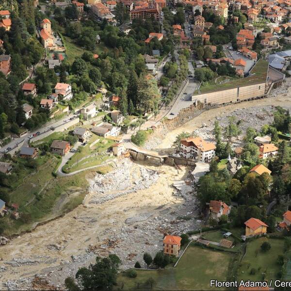
Storm Alex Flood Disaster 2020 (Alpes-Maritimes, France)
On October 2nd & 3rd 2020, storm Alex hit 3 valleys in the French department of the Alpes-Maritimes (La Vésubie, La Roya and La basse Tinée). This particularly violent and stationary Mediterranean event, generated exceptional rainfall with cumulative amounts locally higher than 500-600 mm in 24 hours (Les Mesches: 660 mm/24h), associated with pluri-centennial return periods (of the order of 500 years for La Vésubie and 1,000 years for La Roya). This extreme event claimed 18 victims (10 deaths and 8 missing) and caused damages estimated around €1 billion, with considerable impacts to buildings (171 buildings destroyed, 52 threatening ruin and 134 damaged), infrastructures (30 bridges destroyed, 15 threatening ruin, more than 25 km of road damaged) and networks, isolating some of the communities for several months.
The morphological changes caused by the flood were exceptional, with aggradation levels of over 10 m in places, the fluctuation of the riverbeds by several meters and erosion rates of up to 1,000 m3/ml. The fluvial style was completely altered, from single paved beds to braided beds over almost 35 km, with an active strip widening by a factor of 4 to 5, a phenomena rarely seen to such an extent. Sediment transport by scouring, which could be estimated by comparing DTMs (derived from lidar surveys), is itself extraordinary, with 6 M m3 of eroded material and 3.9 M m3 of deposited material in the upper Vésubie valley".

